USA States – Charts, Maps & Study Tools
A curated collection of USA state charts, maps, study tools, and educational designs created for students, teachers, travelers, and anyone who loves American geography.
Includes 50 states abbreviations charts, map outlines, color variants, study posters, spiral notebooks, stickers, and classroom-ready visuals.
Perfect for learning, homeschooling, classroom décor, study notes, or travel planning.
89 resultados
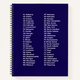
Abreviaturas de los 50 estados – Cuaderno espiral
Precio 31,95 €
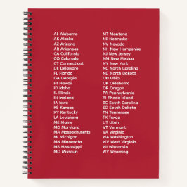
Abreviaturas de los 50 estados – Cuaderno en espir
Precio 31,95 €

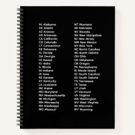
Lista de abreviaturas de 50 estados – Cuaderno en
Precio 21,70 €

Bicolor Taza Lista de 50 Estados en Orden Alfabético
Precio 17,40 €

Camiseta California, Sacramento – El Estado Dorado, EE. UU.
Precio de venta 24,70 €. Precio original 29,05 €.
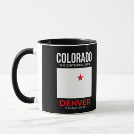
Taza Colorado, Denver – La Ciudad de la Milla Alta, EE.
Precio 18,70 €

Camiseta Colorado, Denver – La ciudad de una milla de altur
Precio de venta 24,70 €. Precio original 29,05 €.

Camiseta Colorado, Denver – La ciudad de una milla de altur
Precio de venta 24,70 €. Precio original 29,05 €.


Llavero Senderismo en Colorado – El Estado del Centenario
Precio 12,90 €


Colorado Senderismo – El Estado Centenario USA
Precio 3,89 €

Imán Senderismo en Colorado – El Estado del Centenario
Precio 6,55 €

Invitación Colorado Senderismo – El Estado del Centenario EE.
Precio de venta 2,16 €. Precio original 2,88 €.

Pegatina Cuadrada Senderismo en Colorado – El Estado del Centenario
Precio de venta 9,06 €. Precio original 10,65 €.

Termo Colorado – Espíritu de las Montañas Rocosas EE. UU
Precio 38,88 €

Taza De Viaje Colorado – Spirit of the Rockies USA
Precio 20,15 €

Camiseta Senderismo en Colorado: El Espíritu Centenario
Precio de venta 32,60 €. Precio original 38,35 €.

Camiseta Colorado Senderismo – La Aventura del Estado Cente
Precio de venta 24,70 €. Precio original 29,05 €.

Cuaderno espiral de 50 estados
Precio 31,60 €
Abreviaturas de los 50 estados – Cuaderno espiral
Precio 21,70 €
Otras colecciones de ChrisVision que te pueden interesar